


**Canadian Rockies**
It is part of the Rocky Mountains in North America. In this part of the mountain range, it is the eastern part of the Canadian Rockies.
The Canadian Rockies stretch from Alberta, Canada, and northeastern British Columbia to Idaho and Montana in the USA.
In the Canadian Rockies, there are five national parks, four of which are adjacent: Banff, Jasper, Kootenay, and Yoho. All five parks were designated as a UNESCO World Heritage Site in 1984.

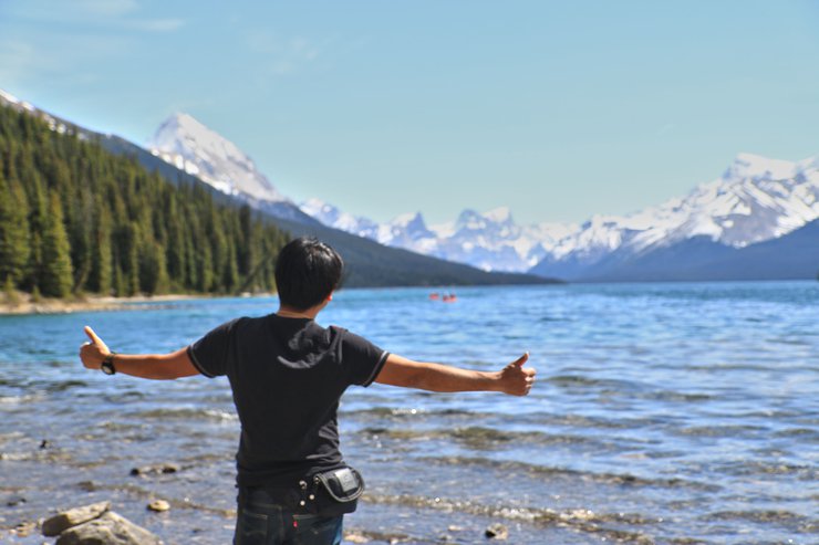
This trip has been planned for months. Inspired by posts on Pantip and friends in the Bay Area in SF who have been there, my wife (not me) really wanted to go. Honestly, I didn't know much about Banff until my wife told me she wanted to go. Then I started researching and realized how beautiful it is.
After returning from Alaska and knowing everyone's class schedules for sure, we finally set a definite date.
We chose the beginning of May because both of us were free, and our older sister, who used to live in SF, was flying back to Seattle for a meeting and would be joining us on our trip. After Seattle, she would fly on to Calgary, a major city in the area, so some friends asked to join us, making a total of 7 people. (Actually, more people asked to join us, but the car was full because I was the only one with an American driver's license. My wife and older sister have international licenses, but they didn't dare to drive long distances.)
The trip consisted of me, the only man in the group (everyone called me "Dad"), who was responsible for driving, planning the trip, taking photos, and cooking (I did almost everything).
My wife (everyone on the trip called her mom) sat next to me and fell asleep.
Big Sister Ying, who prepared a lot of provisions from Thailand (Little Sister Ying said she had been eyeing them for days), was the only one who had an international license from Thailand to help me drive. But she only drove for 20 minutes the entire trip. She has a knack for attracting the police. If you want to know why, keep reading.
Khun Pee Ying Klang acted as an animal spotter. People on the trip believed that Khun Pee Ying Klang had a special power to summon animals. Even after returning, she sent that power to help.
Little sister Lek has a weakness for food. Whenever there's food, she laughs all the time, even though her older siblings tease her all the way. When she doesn't eat, she sleeps.
Stanford's younger sister has a knack for posing for photos. No matter what pose she strikes, she always looks beautiful.
And lastly, our female friend from Canada who works as an accountant. She's incredibly good at math, even better than a calculator (because we can't keep up with her calculations).
Once we had all the members, we chose the airline we would fly with. We chose to depart from San Francisco International Airport, connect in Seattle, and then land at Calgary International Airport with Alaska Airlines.
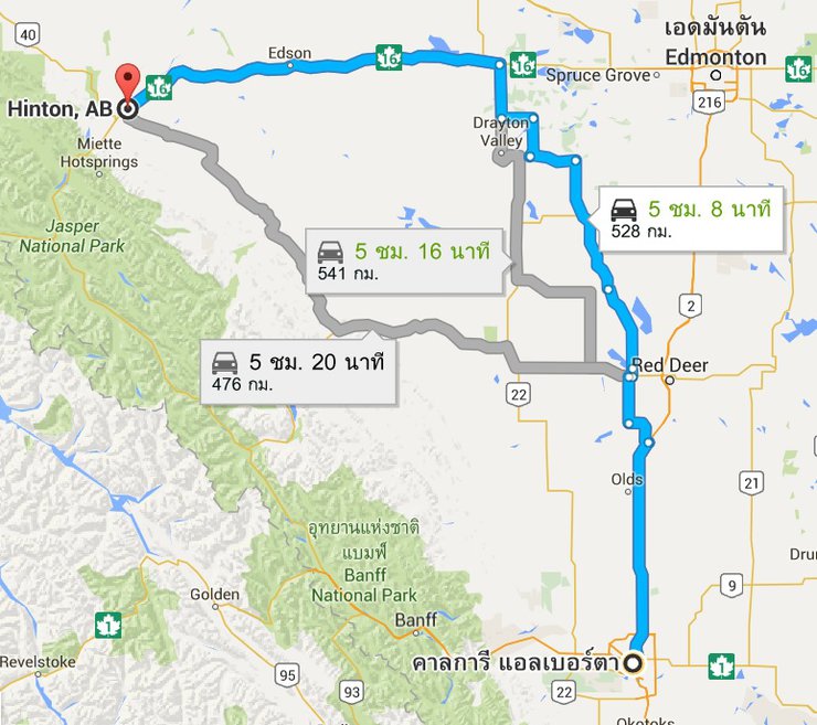
To visit the Canadian Rockies, you can fly into either Edmonton or Calgary International Airport. Both are international airports and are located near each other. However, we chose to fly into and out of Calgary to avoid the extra cost of returning a rental car at a different airport. More importantly, one of our group members had to leave early, and Banff is only 1.30 hours from Calgary.

The next step is the process of applying for a Canadian visa. If you are a Thai citizen and not a US citizen, you will need to apply for a visa. The application process for a Canadian visa must be done entirely online. I will write a separate post about this process later (because it was very complicated and there was no information available in Thai, if applying from the USA).
Our trip started from San Francisco, the city where we are studying (one member of the trip flew in from Montreal, Canada). Our flight departed at 6 am, which meant we had to wake up at 3 am to get to the airport by 4 am. Since it was an international flight, we couldn't check in online and just walk through the gate with our boarding pass on our phones. We had to check in at the airline counter, which wasted some time.
The flight from Seattle to Calgary was on a small plane, only two seats. We flew low and slow, but the problem was that I was seated next to a family that smelled very strongly. I felt dizzy during the flight, not from the plane, but from the smell of the people sitting next to me. When I got off the plane, I was very dizzy.

Calgary
Calgary is a major city in the province of Alberta, Canada. It is located at the confluence of the Bow and Elbow rivers in southern Alberta. With a population of approximately 1 million people, Calgary is the largest city in Alberta.
In 1988, Calgary became the first Canadian city to host the Winter Olympics.
If you've seen the movie The Revenant, for which Leonardo DiCaprio won an Oscar, several scenes were filmed in Calgary.
We arrived in Calgary at 11:40 AM. Calgary time is 1 hour ahead of San Francisco time. Calgary Airport offers free Wi-Fi throughout the airport, which is very convenient.
This trip will be one where we have no phone signal and won't be using social networks, similar to the Alaska trip we just took at the beginning of March. This makes me feel really good about disconnecting from the social world while traveling. We will only have internet access at the hotel, but I've already downloaded all the offline Google Maps.
After passing through immigration at the airport (at that time, I tried my best to avoid walking near the family of guests, because if I still smelled it, I wouldn't be able to drive), I went to the airport car rental center, which was just across the street from the terminal. We had booked a large 7-seater car from Enterprise.
This car right here.

We left the airport around noon. On the first day, we had to drive 5 hours to Hinton, a town north of Jasper National Park. We didn't stay in Jasper on the first night because accommodation in Jasper is very expensive, and Hinton is only 1 hour away from the first place we were going to visit.
The road between Calgary and Hinton starts as a 4-lane freeway, but it narrows to a 2-lane road before reaching the city of Red Deer. This 2-lane section continues for a long distance until you reach Highway 16. The speed limit on the 2-lane road is lower than on the freeway.

On the 2-lane section, I was very sleepy because I woke up early and didn't get much sleep on the plane. Plus, I was dizzy from the smell of the guest's body odor. I really couldn't take it anymore, so I had to let my older sister drive instead. While I was driving, everyone in the car was asleep. As soon as I changed drivers, everyone woke up. I was planning to take a nap for an hour, but after driving for only 20 minutes, something similar to what happened in Alaska happened: a car with flashing red and blue lights appeared behind me. It was a police car! Oh no!
This time we didn't miss it like in Alaska. In Alaska, we didn't know it was a police car, so we didn't stop (and got fined for resisting arrest). But this time, when I saw my beautiful older sister, I immediately pulled over to the side of the road. It turned out to be a handsome young policeman who pulled up alongside and told us we were speeding. Luckily, it was my older sister who was driving. After the policeman told us we were speeding, my older sister immediately took off her sunglasses and gave him a pleading look, admitting her guilt and saying that she was a tourist and that she couldn't slow down in time on the downhill. The policeman's voice softened immediately, and he just gave us a warning. This is why... I don't want to type anymore, or I'll get scolded.
I only rested for 20 minutes after meeting the police officer. Then I drove straight without letting anyone else drive, for fear of attracting more police attention. In the end, we arrived in Hinton around 8 pm (sunset is at 9 pm) because we stopped to eat, buy snacks, and use the restroom along the way.
Date 2
We left Hinton early in the morning. Our first stop was Maligne Canyon, which is about an hour away from Hinton. Along the way, there were beautiful views to stop and take pictures of all the way.

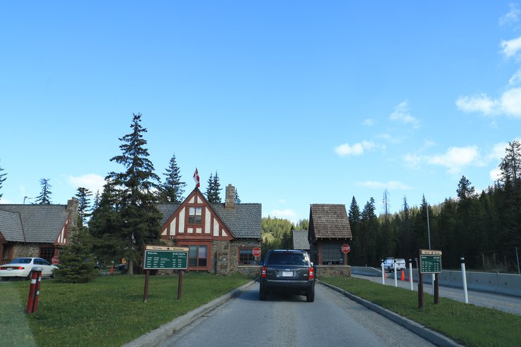
Upon entering, you will encounter a checkpoint where you will be charged an entrance fee. The national park entrance fee will be calculated based on the number of nights you will be staying in the park. Please note that the fee is calculated per night for the entire duration of your stay. The individual fee is 9.8 CAD/day. However, if you are in a group of 7 or fewer people, you can opt for the family rate, which is a flat fee of 19.6 CAD/day. (If you are a group of 2, it is recommended to choose the family rate.) Therefore, when I went with a group of 7, we opted for the family rate. We stayed for 3 nights and 4 days, and the park ranger charged us for 3 nights at a cost of 58.8 CAD. Once you have paid, you will receive a receipt that you must display on your vehicle's windshield. This receipt will grant you access to all of the national parks in this area, including the 5 national parks I mentioned earlier.
(This picture is of a toll booth at Banff National Park.)

It wasn't long before we arrived at our first destination, Marigne Canyon.
Maligne Canyon
It is a natural canyon located in Jasper National Park, eroded from The Palliser Formation with a height of more than 50 meters.
For the Maligne Canyon trail, there are 3 options to choose from: short, medium, and long. The short trail only covers 2 bridges and takes about 20 minutes to walk.
The middle distance is about 3.7 km. It takes about 1 hour to walk. We choose this one.
And the long distance of 6.7 km, this takes a long time, 2-3 hours. It's too long. We don't have much time, we have to go on many more trips.


The trail is a loop. This view is before reaching bridge number 2, which is near the end of the trail.

Leaving Maligne Canyon, we continued driving to Medicine Lake, which is not far from Maligne Canyon. However, it was a pity that the forest fire had turned one side of Medicine Lake into a charred black. We only stayed for a short while as it was not very scenic, just black and burnt.

Our next destination was Maligne Lake, which is about 20 km away. But it was already well past noon, and the girls in the car (6 girls) were very hungry, especially the youngest one. We couldn't let her get hungry because she would get cranky. So we had to find a place to eat quickly. Luckily, not far from Maligne Lake, there was a picnic spot by the Maligne River. So we decided to stop and eat the food we had in the car.


This picnic area is full of squirrels. They almost ran into our legs. They came to ask for food, but please don't feed them.

With a full stomach, it won't be long before we reach Maligne Lake.
Maligne Lake
The largest lake in the Canadian Rockies, stretching 22 km long, is located in Jasper National Park. It is famous for its turquoise water and is surrounded by the majestic Rocky Mountains. From the lake, you can see three Glacier peaks and take a boat to visit Spirit Island, a famous island in the middle of the lake. (Boats are only available from spring to autumn.) The ticket price is 65 CAD per person, which I think is expensive. And from the pictures I've seen, it doesn't seem worth spending 65 CAD. So I didn't go.
There are many trails to choose from around the lake. Try looking for the one you want to walk on http://www.pc.gc.ca/eng/pn-np/ab/jasper/activ/ete-summer/randon-hike/c-2013.aspx

We chose the Mary Schaffer Loop, which is about 3.2 km long. From the parking lot, we walked to the lake and then turned left. This path is easy, not too steep, and has several viewpoints.


We couldn't complete the loop because we had a reservation for the Jasper Sky Tram, which closes at 5 pm. So we had to leave Maligne Lake early.
Before reaching the Jasper Sky Tram, I saw a car parked on the side of the road. I was wondering why it was parked there. When I looked closer, OMG!!! A large herd of Bighorn Sheep was lying on the side of the road. I shouted out loud and immediately pulled over to take pictures.
You can often find Bighorn Sheep in the National Parks around here. During my four days here, I saw them almost every day, sometimes getting photos and sometimes not, but I saw them all the time.
Bighorn sheep are a species of wild sheep native to North America. Their most notable feature is their horns, which can be curved in a circle or pointed and upright.

Next, we went to the Jasper Skytram, a gondola in Jasper that takes you to the top of Whistlers Mountain, 2,277 meters above sea level. The cost is $39.95 CAD per person. http://www.jasperskytram.com/
The top is just red soil, no snow at all. The beauty is that you can see the city of Jasper and the lakes around the city, but the atmosphere on top is very average.


Let's get down soon before the last cable car.

From Skytram, we went to the hotel first to check in. On the way to the hotel, we saw deer walking along the road in many places. But I didn't take any pictures because I don't think it's a rare item that I want to see.
We stayed at the Mouth Robson Inn right in the city center. The accommodation was very expensive in this city, and the rooms were just average. There were many restaurants in the city, but only one large supermarket (which was small), Robinson. Since we still had destinations to visit that day, we had to find fast food to eat. In the city center, there was a KFC and Pizza Hut in the same building. This restaurant was very crowded.

After finishing dinner, we rushed out of town to our next destination, Mouth Edith Cavell. The distance from the city was only 27 km, but Google said it would take almost an hour. The road must be steep. When we arrived at the entrance, it turned out that the road was closed!!! So frustrating.
So I had to find a new place to go, which was Athabasca Falls, not far from Jasper. You can drive there on the Icefield Parkway, Highway 93. But from Mouth Edith Cavell, you have to go another way, a small 2-lane road. But there are a lot of deer (I didn't have time to take a picture).
Athabasca Falls
It is a waterfall on the upper part of the Athabasca River, approximately 23 meters high, located about 30 km from the town of Jasper.

This waterfall flows through a narrow channel into the Athabasca River.

The Athabasca River's water color is so beautiful.

We left the waterfall just as the sun was setting, around 9 pm. On our way back on Route 93A, we saw two cars parked on the side of the road. We knew something must be up, so we slowed down. As it turned out, we came across a black bear eating grass by the side of the road. Oh my God! This was a real rare find. We were so excited, but we could only take pictures from the car. We weren't allowed to get out.
American Black Bear
The American black bear is a medium-sized bear native to North America. It is an omnivore, meaning its diet consists of both plants and animals, depending on the season and location. Black bears typically inhabit large forested areas but may venture outside of forests in search of food.

Everyone says that Big Sister Klang must have performed some kind of ceremony because before that, she was always complaining that she wanted to see a bear.
It's almost half past nine and it's still light outside. The days are really long this time of year. It must be tiring to travel during this time.
Date 3
Last night we didn't have time to buy things at Robinson, so we had to go buy them this morning. And today we left earlier than usual, leaving the hotel at almost 10 am.
Today we will be driving a long stretch on Highway 93A, also known as the Icefield Parkway.
Icefield Parkway
This is the most scenic route in Alberta, surrounded by the Canadian Rockies for most of the way. It passes through Banff National Park and Jasper National Park, connecting the towns of Jasper, Lake Louise, and Banff. The route is over 230 km long.


Our first destination was Sunwapta Falls. We didn't stay long because it wasn't very beautiful, and one of my fellow travelers needed to use the restroom but didn't dare to use the park's facilities. Let me tell you, most of the park's restrooms are pit toilets. I often see images of them that make me want to run away screaming. So, we went to pee behind some trees instead. My fellow travelers, all six of whom were women, decided to hold it until we reached the Columbia Icefield Discovery Center, which was about 50 km from the falls.

The Columbia Icefield Discovery Center is a large office building located opposite the Columbia Icefield.
This is the main office to purchase various tickets, such as tickets for the Icefield Parkway, tickets for the Skywalk, or purchase all-inclusive tickets, including the Banff Gondola. If it's an all-inclusive ticket for 4 things: Columbia Icefield, Skywalk, Banff Gondola, and a boat to Spirit Island at Maligne Lake, if I remember correctly, the price will be around 150 CAD (if I'm wrong, I apologize).
This photo is of the Columbia Icefield, which I took from the Columbia Icefield Discovery Center across the street.

Columbia Icefield
It is the largest icefield in the Rocky Mountains of North America, located in the Canadian Rockies, straddling the border of British Columbia and Alberta, Canada. The icefield stretches from the northwestern part of Banff National Park to the southern part of Jasper National Park, covering an area of 325 sq km.

We opted for the Skywalk glass walkway only, which cost 32 CAD. If you want to walk on the Glacier as well, it costs 80 CAD (there is no option to walk on the Glacier alone, you have to buy it together with the Skywalk). However, the time allotted for both activities seemed insufficient for us, so we chose only one.
You cannot drive your own car to Skywalk as there is no parking available. You must take the park's shuttle bus, which departs regularly. The bus ride takes less than 15 minutes.
From the parking lot, there is a walkway along the cliff until you reach the skywalk. It's not a long walk.


The Skywalk office is located in the upper right corner of the picture. It is the starting point before walking along the cliff.

As we were on the skywalk, we were lucky enough to see another rare animal, the mountain goat, or แพะภูเขา, right below us. The locals told us that this area is home to these animals, and they like to lick the salt that is found in the crevices of the cliff face.


On the way back from Skywalk to Columbia Icefield Discovery Center, there is a bus to pick up tourists every 15 minutes.
We arrived around 1 pm, which was well past lunchtime. We couldn't afford to delay any longer, as our little one wouldn't be able to enjoy themselves as much if they were hungry.
The second floor of the office houses the cafeteria and restaurant, which leads out to the office rooftop, which is also a picnic area. There are tables and chairs for sitting and eating while enjoying the view of the glacier in front. So we went to get our supplies from the back of the car, instant noodles, canned food, snacks, and sat down to eat lunch here.

After finishing my meal, I initially planned to drive to a nearby location to take some photos of the Glacier. However, upon checking the time, I realized that it would be too late, so I had to skip it and proceed to the next destination.
The next stop is Peyto Lake, about 80 km from the Columbia Icefield Discovery Center, which takes more than an hour. When you reach the parking lot, you have to walk through the snow for about 400 meters. The path is quite slippery, but once you reach the viewpoint, it's so beautiful.
**Peyto Lake**
It is a lake located in Banff National Park. The lake is situated in the middle of the Waputik Range valley, which lies between Mount Candron and Mount Peyto. The lake is approximately 1860 meters above sea level.
During the spring and summer seasons, glaciers from both peaks flow into this lake, giving the water a bright turquoise color.


From Peyto Lake, the next location, which is not far away, about a 5-minute drive, is Bow Lake.
Bow Lake
It is a small lake located in the west of Alberta province. The lake is located on the Bow River. When I went there, the ice on the lake had just begun to melt.
We parked our car at the lakeside parking lot. As soon as we got out of the car, my wife said, "It's so cold outside!" (which wasn't true at the parking lot). Because I believed my wife, I only brought a thin jacket. As we walked to the lake, there was a constant cold wind blowing across the lake, plus the ice on the lake. Oh my god! It was so cold! When I took my hands out of my jacket, they hurt. My jacket was thin. The girls on the trip wanted to take pictures, so they had to take their hands out to press the shutter. With the beautiful scenery, the girls couldn't just take one picture. Especially my wife.


Of all the pictures, I like this one the most.

I only managed to take a few photos before the photographer called it a day. Otherwise, we would have been frozen solid by the lake. No matter how much the kids on the trip begged for more photos, we had to walk away. Next time we get out of the car, I'll know to take as many photos as possible.
Next stop, Lake Louise. Originally, we planned to go to Moraine Lake first because it's a very beautiful lake. But, the road was closed! It opens in June. We almost wanted to cry. So we just went to Lake Louise.
Lake Louise
Lake Louise is a renowned lake in Banff National Park, and it also lends its name to a small town in the same area. The lake is named after Princess Louise Caroline Alberta, the fourth daughter of Queen Victoria and wife of the Marquess of Lorne, who was the Governor General of Canada from 1878 to 1883.
This lake has an emerald green color due to the water from the lake coming from the melting of the glacier behind the lake. The lake has an area of 0.8 sq km and flows into the Bow River.


At Lake Louise, there is a famous hotel right on the lakeshore called Fairmont's Chateau Lake Louise. It is a luxury hotel.
At Lake Louise, there are many trails to hike. You can hike to a viewpoint overlooking the lake, which is very beautiful. You can also hike to a tea house at the back of the lake, which has stunning views. However, we did not go up there because we had to go to sleep in Canmore, which is another hour away.

From Lake Louise, you can choose two routes to Canmore or Banff:
- 1. Take the freeway number 93, which allows for faster driving and takes less than 1 hour.
- 2. Take route number 1A, which is a smaller road through the forest. The speed limit is only 60 km/h due to the abundance of wildlife.
We opted for the freeway because it was getting dark, everyone in the car was extremely hungry, and we were all very tired.
Upon arriving in Canmore, we checked into our accommodation at Mystic Spring Chalet & Hot Pool. It felt like having an entire house to ourselves, complete with a kitchen, two bedrooms, a living room, and two floors. Having a kitchen made self-catering a delightful experience. Canmore has a large Safeway supermarket in town, so we were able to stock up on groceries.


Canmore
It is a mid-sized town nestled in the heart of the Canadian Rockies, approximately 80 km from Calgary (a 1-hour drive to the airport) and 30 minutes from Banff.
We chose to stay in this city because the accommodation is not as expensive as in Banff, and we had to drive two members of our trip to Calgary Airport first, and then come back to visit Banff again. Canmore is located halfway between Banff and Calgary.


Date 4
This morning, Big Sister and Middle Sister had to fly back to Calgary in the late afternoon. We had to drive them there, but we still had some time in the morning. Our morning program was the Banff Gondola.
At the Banff Gondola, there is a spacious parking lot and an office building with a coffee shop and gift shop. The cost to ride the Banff Gondola is CAD 42 per person.


Banff Gondola
The gondola, which takes us up to the top of Sulphur Mountain on the east side, at an altitude of 2,256 meters, has a long wooden walkway on the top.


We can see the Bow Valley and the town of Banff.


On my last trip to Alaska with three women, the owner of the sled dogs asked me, "What is your secret?" At first, I was confused and asked, "What secret?" He meant, "What is your secret to being able to travel with three women?"
On this trip, there were 6 women. I saw the person who took the picture for them smiling and laughing. If I see the uncle again, I will tell him that being the only man doing everything on the trip is super tiring. Would you like to try it sometime? Hehehe.
The only photo that has everyone in the trip happened here.

Another lucky climb, another rare animal encounter! This time, it's the Columbia Ground Squirrel. See if you can spot it in the picture.

It took a long time to get to the top because the wooden walkway was quite long.

As we descended, it was almost noon. There was no place for us to picnic at the Banff Gondola, so we decided to find a place to eat at the next stop. The next stop was Surprise Corner, where we could take pictures of the opposite side of the Fairmont Banff Spring Hotel, which is very beautiful and located next to the Bow River.
We'll have lunch right here at Surprise Corner.

It's time to take Big Sister and Middle Sister to the Calgary airport. The drive from Banff to the airport takes about an hour and a half. We chose to take Tunnel Mountain Road to enjoy the view before getting on the freeway to Calgary.
After we finished the delivery, we passed by Tunnel Mountain Road and saw a viewpoint with beautiful red chairs. We decided to come back after dropping off the two ladies.
I don't know what to call this.


After this point, I would like to walk around Banff town in the late afternoon.
Banff Town
Banff is a mid-sized town located within Banff National Park, surrounded by the valleys of the Canadian Rockies. The town sits at an elevation of approximately 1,400 meters above sea level. Banff is considered a resort town in Canada, with numerous resorts, and prices tend to be relatively high.
The bridge in the middle of Banff town. There are many parking spaces near the bridge. You can park your car near the bridge and walk around town or walk to see the Bow River.


Bow River

After leaving Banff, we returned to our original accommodation in Canmore.
Date 5
Our last day in Banff has arrived, and we're determined to make the most of it by exploring every nook and cranny of this stunning national park. Our first stop is a scenic drive along the Bow Valley Parkway, also known as Highway 1A.
Bow Valley Parkway
This is a road that runs parallel to the main road. The road starts from the town of Banff and ends at the town of Lake Louise, a distance of approximately 65 km. It is a small road with two lanes in some sections and four narrow lanes in others. However, the speed limit along the entire route is 60 km/h because this road is home to a large number of wild animals.
Along this route, you will encounter park rangers checking the Park entrance fee receipts that we must display on the front of our vehicles. So please be prepared.
The first stop on our journey is Johnstone Canyon, a canyon located in Bow Valley Parkway.
Johnstone Canyon
This is a canyon located in Bow Valley Parkway. Tourists must hike down to the bottom of the canyon, where there is a steel walkway built alongside the canyon. The hike consists of a short trail to the lower waterfall, a distance of 1.1 km, or you can continue from the lower waterfall to the upper waterfall, a distance of 2.7 km. Alternatively, tourists can hike the long trail to Ink Pot, a distance of 5.8 km.


Lower Fall, Johnstone Canyon

For us, we chose to walk only to the Upper Fall, a distance of 2.7 km.
Upper Fall, Johnstone Canyon

We spent almost 2 hours walking and taking pictures. By the time we came out, it was already afternoon. We had lunch at the picnic area near the Jonstone Canyon parking lot, which was full of picnic tables and had excellent restrooms.
While I was on my way to the car to get supplies, I came across this creature: a Red Fox. The locals told me that this animal is extremely rare to see. The person I spoke to said that he has been living in Banff for 28 years and has only seen a Red Fox four times. Wow! But this one came down to the parking lot and everyone was taking pictures of it.


After lunch, the next stop was a scenic viewpoint on Castle Mountain. Since it had just rained the previous night, the wildflowers were in full bloom. It was truly beautiful, with Castle Mountain as the backdrop.

Along the way, there are scenic viewpoints scattered throughout.

We drove around to find rare wildlife here. After driving for a while, we saw 2-3 cars parked on the side of the road. So we slowed down and saw a moose. Oh my god, when I went to Alaska, I didn't see this guy. I came to see him here.

I didn't see anything else while driving, but I did see deer and bighorn sheep quite often. I didn't take any pictures.
After leaving Bow Valley Parkway, we had a few lakes to see in Banff before heading back. The first stop was Vermillion Lake.
This photo was taken on the side of the Icefield Parkway last night when it was raining. Wildflowers are blooming all along the way.

At first, I saw this Lake from above, it didn't look beautiful at all. The water color wasn't pretty, and there were long yellow grasses growing all over it. It looked like a pond near my house, but my wife and the rest of the trip told me that if I was already here, I had to go.
Before entering, I was confused as to why there were so many park ranger vehicles parked on the side of the road. So I jokingly said, "I guess there's a bear running around." It turned out that when we reached the lake, it was true!!! The Grizzly Bear was chasing birds at the lake. People were parked far away watching. I was so happy, I parked the car and ran to take pictures as close as possible. My wife then said, "How about that? Does the swamp near your house have a Grizzly Bear to show you?" 5555

The grizzly bear is a large, ferocious bear. It is very fast, so it is important to stay away from it. On average, it weighs between 180 and 360 kg and is almost 2 meters tall. It is found mainly in western North America.
I'm happy now. I've almost collected all the rare animals.

After watching the bears, I looked for a spot to take photos near the lake. An old man came up to me and started talking. He said he was from a neighboring province called Saskatchewan. I couldn't believe it was a city in Canada, it sounded like a place near my hometown. He told me to look across the lake, saying there was a moose. I looked for ages but couldn't see anything. He said maybe it wasn't there anymore, he thought he saw it. Then he called me over to the lake to take a picture of a duck instead... He was messing with me. People here are nice, friendly and a little funny. I thanked him (but didn't take a picture of the duck) and went back to my car.
This is Vermillion Lake

The next place we went to was Johnson Lake, which is about 12 km from Vermillion Lake.


Adjacent to Johnson Lake is Two Jack Lake. This lake has an island in the middle, but most importantly, it has two red chairs that everyone is looking for because it's one of the pictures in the brochure that the park rangers gave us, and everyone is talking about it.

The last lake of this trip, Lake Minnewanka. This lake has a boat tour that takes you around the lake and shows you various wildlife. It costs 60 CAD per person, but it was closed when we went.


From the last lake, we drove straight to Calgary. We spent our last night in Calgary because the next day, my wife and I had to catch a 6:00 am flight to Seattle. An unexpected event occurred, causing us to miss our flight.
We arrived at Calgary Airport at 4:00 AM, with plenty of time to catch our 6:00 AM flight. After checking in, we breezed through US immigration, which is located in Canada at the airport (for those flying from Canada to the USA, there is a separate immigration checkpoint before boarding). We had a minor issue during the baggage scan, but it was quickly resolved.
Attention everyone! For carry-on luggage when entering the USA, bags are heavily checked. Liquids must be packed in a zip-lock bag and must all fit in one bag. If it doesn't fit, throw it away! We had to throw away a lot of stuff.
Everything went smoothly until we boarded the plane and fell asleep. When we woke up an hour later, my wife thought we had already arrived in Seattle. However, the plane had not even taken off yet. The captain then announced that the plane had a technical issue and that everyone needed to disembark and wait at the gate. This caused a lot of chaos, especially for passengers who had connecting flights. As for us, we were relaxed because we were going to Seattle anyway.
We sat and waited for a while, chatting away, until we noticed other passengers from different airlines mingling in the same gate as us. This was because our flight had made an emergency landing. As I was talking to my wife, I turned around and realized that all the passengers who were supposed to be on our flight to Seattle had vanished. There were only unfamiliar faces staring back at me.
I ran to the counter to ask, which had been changed to WestJet (we were flying Alaska Airlines), where the Alaska Airlines flight to Seattle had gone. They replied that it had already left and that they were a different airline and didn't know anything about it.
We asked for help on what to do, and they told us to look at the board and find an Alaska Airlines agent. But when we got there, all the Alaska Airlines agents were gone.
We ran to the board and it didn't show anything. We ran to the gate with Alaska Airlines and there were no staff. We went back to the board and it said our flight had already taken off. Oh my god.
We then went back to the original gate to ask the WestJet staff for help, but they were of no assistance. An Alaska Airlines staff member happened to be nearby, so the WestJet staff called them over (the Alaska staff member was in the jet bridge walkway).
Alaska Airlines staff solved the problem by issuing a new flight ticket, but it was for the 12:30 p.m. flight. I had to go outside the gate to get a new ticket and go through immigration again. In total, I wasted 6 hours. T_T I will never be so engrossed in conversation that I don't listen again.
Bye Bye Canadian Rockies Until we meet again


Birdybird
Friday, September 27, 2024 10:05 AM