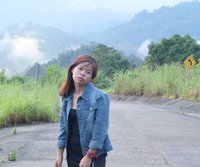


**Khao Daeng** is located within the Sam Roi Yot National Park, Khao Daeng Subdistrict, Kui Buri District, Prachuap Khiri Khan Province. It is situated in the Khao Daeng village. The best time to visit for the most stunning views is during sunrise, as the sun rises directly from the sea on the Khao Daeng side. However, we missed the most beautiful moment and arrived around 10 am, when the sun was already high and hot.
This is the road before the climbing point. It is a long, straight road with towering mountains on both sides. The sky and clouds are incredibly beautiful today.


This trip was with two friends, driving following the GPS. We set the pin at the Khao Daeng viewpoint, but the map took us to a temple instead. Don't worry, we asked the vendors at the temple where the trailhead was, and they said it was just a little further.

The entrance sign to the climbing point. The trekking distance up the mountain is approximately 400 meters, taking about 30 minutes. If you stop frequently, it may take longer.

From the entrance sign, can you see the peak up there? That's where we're going to climb (probably some peak, we're not sure either).

The starting point is located near a park ranger. A sign on a wooden barrier reads "No entry after 4:30 PM." Another sign on the side states, "Please contact the park ranger (at the park office) before 8:30 AM and after 4:30 PM. Violators will be fined 500 baht." This is likely for the safety of visitors. There is no entrance fee for Khao Daeng.

Recommendations for Reaching the Khao Daeng Viewpoint
**Wear sneakers** as the ascent involves climbing over uneven and sharp rocks with a steep incline. Frequent scrambling up and down rocks necessitates sturdy footwear. Other delicate shoes may not withstand the challenging terrain, potentially hindering your progress and enjoyment of the hike.
Another important item is drinking water. When you're tired, taking small sips of water can help quench your thirst. A small bottle is sufficient; there's no need for a large one. Minimize your luggage weight as much as possible. I tucked my water bottle into the back of my pants because I needed both hands to climb over rocks most of the time. I also only brought one camera, which I carried on my shoulder. When moving, I just had to be careful not to bump the camera against the rocks. (You can bring a backpack or bag if you want, depending on your strength.)
Please dispose of your empty water bottles by bringing them down to the bottom or taking them home with you. Do not leave them on top. If you see any garbage along the way, please pick it up and help us keep our tourist attractions clean and beautiful.
Essential oils, inhalants, balms, and pain relief ointments are recommended for potential use.

The image depicts a steep incline, not a flat path. It is important to note that ascending this incline is not an easy feat. The more effort and speed exerted, the faster fatigue will set in. It is recommended to walk slowly and take breaks when necessary. Avoid overexertion or impulsive actions.

There is a rope to hold on to for a while on a very steep path.

Climb on, the heat must be endured, beautiful views await us.

As we ascended, we occasionally questioned whether we were on the correct path due to the absence of clear signage. At certain points, yellow oil paint was used to draw small arrows on rocks, indicating the direction. These arrows were easy to miss, so we paid close attention to our surroundings and the trees around the trail. If the vegetation became dense and impassable, we avoided pushing forward and instead opted for clearer paths. The sheer number of people who had climbed the mountain had left some rocks polished smooth. We followed their footsteps, ensuring our safety and progress.
It is uncertain when we strayed from the correct path, but we remained cautious. If the trail required us to push through vegetation, we assumed we were off course and returned to locate the directional arrows. (This is based on the firsthand experience of two women who lack significant footprint interpretation skills. Typically, when walking on sidewalks or footpaths, close observation is unnecessary.)
Even during the day, I still get lost easily. At night, it's even worse.

When you're tired, take a break. When you can't go on, pull each other along. Prepare some smelling salts and take a sniff or two when you feel dizzy. It will refresh you.
The midday heat was scorching. The more exertion, the more sweat flowed like a stream.

The sign indicates that the summit is within reach, approximately three bends ahead. (These bends are likely winding around a mountain.)


And so, the two of us dragged ourselves all the way to the mountaintop.
"It's just as beautiful as in the pictures!" (An exclamation from someone who has seen many reviews.)


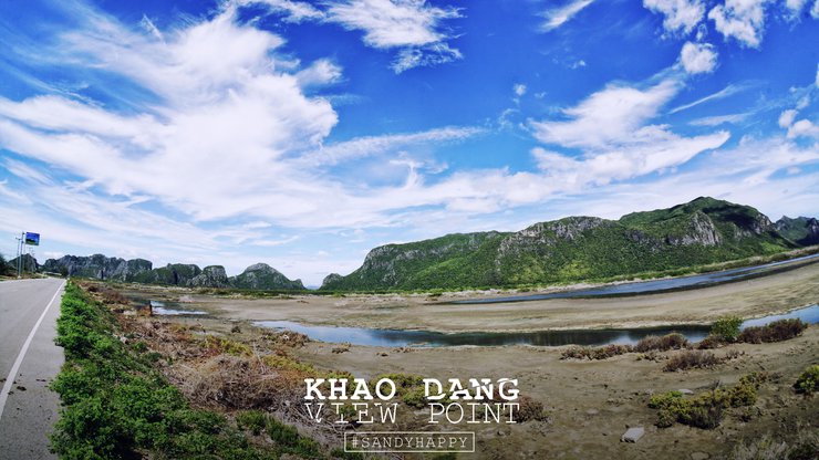
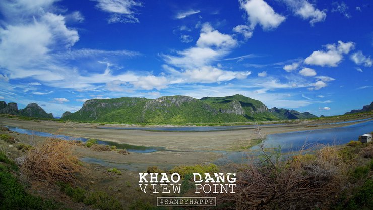
The photo is worth the effort. Below is the Khao Daeng village. This is the view that I saw from other people's reviews. Now I have my own review to show off.

As we boarded, a group of girls got on before us. We helped them take a group photo, and they took one of the two of us in return.
Group selfies often capture only faces, obscuring the beautiful scenery behind. To capture both the group and the view, consider asking someone else to take the photo. This way, you can return home with a stunning group photo that showcases the landscape.


The photo with the sign that I used to think was so popular. Now that I'm here at the top of Khao Daeng, I can't help but feel proud of myself for being able to reach this point.


The absence of tall trees to provide shade meant that I was exposed to the full force of the sun. I roasted myself, turning back and forth until I was cooked to perfection, with a delightful char.


This HTML code represents a horizontal rule (hr) element. In plain English, it translates to:
A horizontal line.
This line is typically used to separate different sections of content on a webpage. It can also be used for visual emphasis.
After taking turns taking photos from various angles until our hearts were content, we descended. The descent was quick and agile, and we no longer feared getting lost. This was because the perspective during the descent made it easier to identify the rocks compared to the ascent (perhaps it was just my imagination!).


Both returned safely, but the companion was bitten on the wrist by a large forest ant. Upon arrival, the hand was visibly swollen. Reading information on the internet, it is said that the venom of this ant can cause paralysis or blindness. I told my companion to put away his phone and not to believe everything on the internet. After all, from someone who is not seriously injured, it may turn out that we are near death because of this misinformation.
Note: The puppy is only experiencing swelling, burning, and stinging pain from the venom. Fortunately, it has not yet developed an allergic reaction, and it is currently doing well.
The arduous ascent of Red Mountain
The half-hour climb to the summit of Red Mountain, a mere 400 meters, felt like an eternity. The oppressive heat, relentless fatigue, and constant need to scramble and search for trail markers made the journey seem interminable.
The sentence that called out to the younger brother in front, "Take a break, I can't take it anymore," still echoed in his ears, along with the panting sound, like a dog panting in the sun, panting.
This adventure-filled trip was a unique and exhilarating experience. The physical exertion involved added to the thrill, making it an unforgettable adventure. While hearing about it from others can provide a glimpse, it doesn't capture the full essence of the experience. The sense of accomplishment and pride that comes with completing such a challenge is something that can only be truly appreciated by those who have undertaken it themselves.
"We've already been to the Khao Daeng viewpoint."
Follow our small page for casual travel and gossip, like chatting with a friend.
"San Dee is happy, and the readers are happy too."


SandyHappy
Friday, September 27, 2024 10:41 AM