


The White Elephant Mountain is now open... So what? Don't even mention booking a trip, even making a phone call is difficult. So I have to keep the popular mountain in my heart and look for another mountain that is easier to visit. Looking and looking, I finally clicked on the Sannorkwao, Khao Laem National Park. I've heard the name for a long time, everyone says it's beautiful, and it's not that far from the White Elephant Mountain. The atmosphere is similar.
To conquer the San Nok Wua ridge, you must book a trip with Khao Laem National Park, similar to how you must book a trip with Thong Pha Phum National Park to climb Khao Chang Puak. However, booking for San Nok Wua is much easier. For details from 2016-2017, please visit the park's Facebook page >>> https://goo.gl/DE6FgM. Please note that this year, the park is only open on Thursdays, Fridays, Saturdays, and Sundays, and will remain open until February. The exact closing date will be announced by the park.
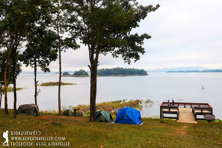
The park's tourist service center is located at the Pom Pi viewpoint, on the banks of the Khao Laem Dam reservoir in Sangkhla Buri district. It is a short distance from the park headquarters. Visitors do not need to stop at the headquarters, as all inquiries can be made at Pom Pi, including campsite registration. The iconic Mon Bridge is approximately 35 kilometers beyond Pom Pi.

Our five-person team for this trip came together through a Facebook invitation, including both old and new friends. We opted for personal vehicles for the journey from Bangkok, due to time constraints. (For those without a car, I will provide a summary of the trip at the end.) We departed the capital in the afternoon, making stops for supplies and food along the way. By the time we reached Fort Pi, it was already evening.
The campsite was moderately crowded, with most groups preparing to ascend Mount Nok Wua early the next morning. However, some visitors chose to simply camp and enjoy the atmosphere. The spacious campsite offered two zones, allowing campers to choose their preferred location. Security was excellent, with park rangers patrolling throughout the night.

A new morning has arrived, the sky is overcast but the air is fresh. Here are some photos of the atmosphere.


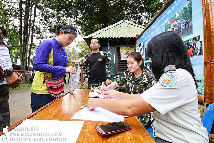
The fort provides all necessary amenities. After storing your belongings, you can have lunch at the welfare canteen and order a packed lunch for the next day. Then, register and pay the fee at the table set up in the parking lot.


Once the formalities are completed, it's time to hop on a pickup truck for a 10-kilometer journey to the trailhead. While the road is in excellent condition, driving yourself is not an option. The trailhead is located within the Kanchanaburi Reporting Station, also known as the Air Force Radar Station, and access is restricted to authorized vehicles only. Additionally, there are no designated parking areas for private vehicles.
After a short car ride, we arrived at the starting point of our hike. Today, there were about ten groups of people climbing the mountain. Our group of five hired a porter to carry some of our food and equipment. We also had a guide with us. There was plenty of water available on the mountain, so we only needed to bring enough for our needs.


The initial 8 kilometers to the summit are relatively easy, with a gradual incline rather than a constant ascent. There are even sections of flat or extended downhill terrain (which will be challenging on the return trip). This allows for a good pace without the need to rush.


Automatic cameras are installed on trees at multiple points along the trail. Officials said they belong to a foreign survey team. They also found that Khao Laem National Park is still home to many large animals, including tigers. Hearing this made me feel quite happy.

Our journey began shortly after nine o'clock. We walked intermittently, and by approximately 11:40 AM, we reached the most challenging ascent of the ridge, aptly named "Dog Retreat Slope." The choice to continue or turn back was entirely up to us. (laughter...)

The aptly named "Dog Retreat Hill" lives up to its reputation for being a steep climb. The park has thoughtfully provided ropes at various points to assist with the ascent. The incline stretches for a considerable distance, which I estimate to be close to half a kilometer.


Emerging from the slope, they managed to reverse uphill. The condition of each person is as you can see.

As we ascend the Ma Thoi slope, we are greeted with panoramic views of the Khao Laem Reservoir and the Air Force radar station perched atop the bare hill (the road we are on leads to the summit of Khao Lon). Years ago, before the Air Force claimed the hilltop, we could hike and camp on Khao Lon before continuing to the San Nok Wua ridge. However, this is no longer possible.


After a refreshing lunch break, we continued our journey, tackling a few more small hills. These hills, however, were not as challenging as the steep "Dog Retreat" hill we had conquered earlier.


At 2:40 PM, we finally arrived at the campsite, with the majestic silhouette of the Little Humpback Mountain towering before us.


The ridge of Khao Nok Wua has two main points: the small ridge and the large ridge. The small ridge is only a 200-meter walk from the campsite, while the large ridge is about 500 meters away. The large ridge is the highest point in the park, at 1,767 meters.
It has been whispered that the peak previously considered the highest in Kanchanaburi has been surpassed by a newly discovered peak in the Thungyai Naresuan Wildlife Sanctuary. However, the information has not been officially updated, and the signage indicating the previous peak's elevation remains unchanged.
"Enough chit-chat, let's set up camp! The other flat spots are already taken. We'll take this slightly sloping area; it's good enough to sleep on and the trees provide some shade."


The advantage of hiring a porter is that, in addition to helping gather firewood, they can also fetch water. The stream is about 500 meters from the campsite and is quite steep, so it would definitely be tiring to walk there yourself. I can say this with confidence because I went to take pictures myself (haha...).
With ample time to spare, we prepared some simple meals beforehand, including stir-fried vegetables, omelets, and fried sausages.


Around five in the evening, when the sun is setting and the wind is calm, I will walk to the viewpoint. I would like to visit both the small ridge and the large ridge. I can either walk between them or go to each one separately.
The view from the small ridge reveals the tent camping area at Khao Laem Dam. In the distance, the bare hill, or radar station, is visible. Turning to the other side, the large ridge comes into view.


Ascend to the summit of the larger ridge, where the smaller ridge stands out prominently against the backdrop of the previously observed scenery. The view is breathtaking, especially during the twilight hours.


After taking stunning and hilarious photos until the sun dipped below the horizon, we cautiously crept back down to the campsite with our flashlights.


Let's continue cooking together until it's done. The simple rule for camping in the forest is: if it's edible, eat it; if it's not edible, you still have to eat it (haha...). But seriously, our chef is very skilled. Everything is delicious... I'm not exaggerating.


The night sky was adorned with a dazzling array of stars, their brilliance illuminating the darkness. The air was pleasantly cool, devoid of the biting chill of winter.


At 5:00 AM, the alarm clock's piercing sound jolted me awake. I emerged from my tent and roused my companions. We grabbed our water bottles and flashlights and formed a line, becoming the first group to ascend the ridge. The strong wind on the summit sent shivers down our spines.
Although there was no spectacular sea of mist that day, with thick fog only over the reservoir, we were not disappointed. We are always happy to encounter nature in any form. The beauty of the morning at San Nok Wua is best described by the pictures.


Stunning from every angle. Every turn, a captivating sight. The camera shutters couldn't keep up.


We enjoyed the view and took photos at the Big Ridge until around 7 pm. Several other groups started to walk up from the Small Ridge to the Big Ridge, so we decided to head down. Once there were no other people around, we had fun taking photos.


The group descended as the second-to-last. Looking at the clock, it started at 9:50 AM. Walking and resting, the way back was quite tiring (I told you that on the way up, we were able to walk down easily at several points). In fact, it was no less tiring than the way up, except that it was easier to descend the dog's slope. It was exactly 1:00 PM when we reached the bottom. A car was waiting to take us back to the fort. We took a shower and headed back.

Although it was a short trip of two days and one night (excluding sleeping at the fort), I must admit that the trail was very beautiful. The hike was not too difficult, and the park rangers were very helpful. The porters also provided excellent service.
The park's limited opening period of approximately four months per year, coupled with restrictions on visitor days and numbers, ensures the sustainability of nature-based tourism.
As mentioned in the title, if booking a trip to Khao Chang Puak is difficult, consider visiting San Nok Wua instead. The scenery may be different, but the experience is guaranteed to be just as memorable.
Information
- Booking a trip to San Nok Wua has clear regulations and designated days for visits (this year, open from Thursday to Sunday). For more information, contact the National Park directly via their Facebook page >>> https://goo.gl/DE6FgM or call 034-510-431.
- Hiring porters is not mandatory, but at least one park ranger is required to guide the group for safety reasons.
- Driving from Pom Pi to the starting point is not allowed. Visitors must use the National Park's shuttle service.
- There is a water source about 500 meters from the campsite. The water is clean and safe for cooking and drinking (boiling it first is recommended for those who are concerned), but not for bathing.
- There are no toilets or trash cans on the mountain. The National Park requires all trash to be brought down and prohibits burning trash on the mountain. However, campfires for cooking are allowed.
- Camping and hammock hanging are both possible on the mountain. However, hammock users may need to find a location further away from the group.
- The Pom Pi viewpoint has all necessary amenities, including toilets, showers, and a restaurant open from morning to evening.
Costs with the National Park
- Guide fee: 1,000 THB per person (2 days 1 night)
- Porter fee: 1,400 THB per person (2 days 1 night)
- Roundtrip transportation fee: 1,000 THB
- Tourist fee: 40 THB per person
- Car fee: 50 THB per car
- Camping fee: 30 THB per person per night
Getting to Pom Pi without a private car
Traveling to Sangkhla Buri is similar to reaching Fort Pi.
- From Kanchanaburi Bus Terminal, there are vans and buses running on the Sai Yok - Thong Pha Phum - Sangkhla Buri route. The last van departs around 4:30 PM, while the last bus leaves no later than 1:00 PM. These are approximate times, so it's recommended to check the latest schedule before traveling.
- From Bangkok, there are tour buses operating on the Bangkok-Dan Chedi Sam Ong route, passing through Fort Pi. These buses depart in the morning, with two trips per day: 6:00 AM and 9:30 AM. The journey takes approximately 7 hours.
- There is a free train from Thon Buri Station departing at 7:50 AM and arriving at Nam Tok Station in Sai Yok District in the afternoon. From there, you can take a van or bus to Fort Pi.
- Once you reach the entrance of Fort Pi, there are no public transportation options available for the remaining 2 kilometers. You can either walk or hitch a ride with other tourists who might be heading in the same direction.
Follow my travel adventures on another channel:
http://www.facebook.com/alifeatraveller


นายสองสามก้าว / A Life, A Traveller
Friday, October 4, 2024 3:08 PM