


>> Follow our travel stories on Facebook at Hello Stranger Page
https://www.facebook.com/hellostrangerpage/
>> IG : hellostrangerth
https://www.instagram.com/hellostrangerth
.
.
Pitukrok Waterfall: A Majestic Cascade in Thailand
The Pitukrok Waterfall, also known as Pertoh Lo Su Waterfall, is a breathtaking natural wonder located in the Umphang Wildlife Sanctuary, Umphang District, Tak Province, Thailand. Situated atop the Sam Mun Mountain Range, this waterfall holds the title of the largest and tallest waterfall in Thailand, boasting a height of over 500 meters (measured by GPS), nearly twice the height of the Baiyoke Tower.
The waterfall's grandeur stems from the confluence of two streams originating from Doi Mamuang Sam Mun, which converge at a steep cliff, forming a magnificent heart-shaped cascade. The sheer volume of water cascading down the cliff face creates a mesmerizing spectacle, leaving visitors in awe of its raw power and beauty.
Journey to the Waterfall
The journey begins in the Umphang district of Tak province, following the Umphang-Ban Beung Kling route for approximately 60 kilometers, a two-hour drive. This leads to the Kui Le O village, from where a two-to-four-hour hike along the mountain range and streams is required, depending on individual walking speed, to reach the campsite. A further two-hour trek leads to the waterfall itself.
Rules and Regulations for Visiting Pitukrok Waterfall
1. Adhere to the rules of the Ban Kui Leot Community Forest.
2. Register / Number of tourists with a fee of 20 baht per person
- Local guides/porters should be used to navigate the area.
5. Camping is permitted only in designated areas marked by the Ban Kui Le Forest Community Committee.
6. It is advisable to contact local guides / porters in advance.
Contact Number
Village headman of Kui Le O To, Tel. 093-0452932
Assistant Village Headman of Kuy Leot, Tel. 088-4299805

From "Khamsing Homestay," where we stayed, changed clothes, and prepared food, we began our journey to the Ban Kui Leut community. After a two-hour car ride, we arrived at the starting point of our hike.

Area before the starting point

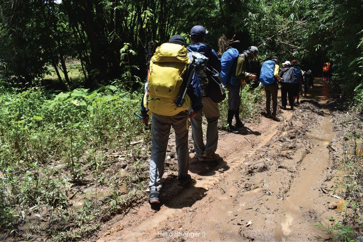
After a 10-minute walk on a smooth road, we encountered a path in this condition.

Please don't take pictures yet, brother. Come help me up first. Haha.

We trudged through the muddy quagmire for a while before wading through the water.

Though the destination seems close, the journey is long and arduous. Nevertheless, we must persevere and reach our goal.

Wading through mud and water, even though the path wasn't very steep, still made us out of breath.

The roadside ginger lily... its beauty alleviates the fatigue of walking a little.
The sentence is already in English and does not require translation.


Lunch break by the roadside, near the stream.

A delicious rice and fried egg wrapped in a banana leaf. Perhaps I'm just hungry. 555

After a two-hour hike, we arrived at the campsite.

Take a break to recharge before continuing to the waterfall.

The two-hour hike from the campsite to the waterfall was challenging due to the alternating steep and flat terrain, exacerbated by the persistent rain that made the path slippery and wet.

Behold, the heart we seek: the "Heart-Shaped Waterfall".

I had only seen it in pictures before, but when I saw it in person, wow... it was truly as beautiful as its reputation.

After being drenched from walking in the rain, we were able to take a refreshing shower at the waterfall, which was located a short distance from our campsite.

Thank you to all the strangers for this journey and it was a pleasure to meet you.
This trip was a collaboration with the "Koo Tiew Pai Reur" page. Overall, it was a fun experience, even though we were tired and exhausted at times. We are very grateful to all the strangers who helped us along the way, and we hope to travel together again in the future.
#Hello stranger
Greetings.


สวัสดีคนแปลกหน้า
Tuesday, October 8, 2024 11:32 AM