
![cover [ ★ ] Conquer "Pha Ti Doi - Mue Ko Da Doi Lung Doi Pa" once in a lifetime (3 days 2 nights Oh !! It's better to crawl :)](https://asset.readme.me/files/53560/cover.jpg?v=20964885)
![cover [ ★ ] Conquer "Pha Ti Doi - Mue Ko Da Doi Lung Doi Pa" once in a lifetime (3 days 2 nights Oh !! It's better to crawl :)](https://asset.readme.me/files/53560/thumb.cover.jpg?v=20964885)

Phadoe and Mu Ko Do, two scenic mountains with challenging names, are another peak that hikers like us must conquer at least once. No matter how far away it is, we will still travel there. What is the terrain like? Will it be as beautiful as its reputation?.... I don't know anything about it, except that it is located in #PangOung #KhunYuam #MaeHongSon. . . . We must set out to find out, and every time I travel, I make new friends and return with many of them.
When it comes to the difficulty of trekking, Pha Ti Do - Mu Ko Do? How difficult is it? Hehe... I don't know either!! You have to try it yourself to find out, and you'll be hooked.
Doi Pha Ti Do - Mue Ko Do is a mountain range located on the border of Mae Suek Subdistrict, Mae Chaem District, Chiang Mai Province, and Mae Yuam Noi Subdistrict, Khun Yuam District, Mae Hong Son Province. Based on the actual land area, the mountain peak is considered to be located in Mae Hong Son Province. However, the access road is located in Chiang Mai Province. These two high mountains in the northern region, although not far apart, are located in different provinces. This is similar to the origin of the name of this mountain range. According to local accounts, the name suggests a history of conflict and separation.
+++ Follow us for more updates. +++
FB: Travel to make people jealous
Readme Reviews: Travel to make people jealous

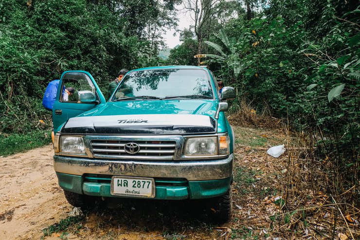
The journey from Bangkok to the starting point of the Pha Ti Doi - Huai Mae Kam Doi Lung Doi Pa trek, a 3-day, 2-night adventure, took over 16 hours by car. "It's not as far as I thought, but wow! It's better to crawl :)" We passed through Thein, Li, Hot, Mae Sariang, Khun Yuam, and finally reached the Pang Ung Royal Project. The checkpoint at Ban Pang Ung is located in Mae Saek Subdistrict, Mae Chaem District. However, halfway through the car ride, we entered the territory of Mae Yuam Noi Subdistrict, Khun Yuam District. Upon arrival, it was almost noon, and we switched from a van to a local pickup truck to better navigate the terrain. The starting point of the trek was about 10 kilometers away.

The road was initially paved, passing through villages. After a while, it took us on a bumpy ride on a gravel road. The muddy path was an adventure, with small and large mountains alternating on both sides, providing a beautiful view for taking pictures. Rain kept falling to welcome us.


We arrived at the trailhead for Doi Pha Ti Doi at 2:00 PM. Our goal for the day was to hike to the summit of Doi Pha Ti Doi, a distance of approximately 4 kilometers, which would take us an estimated 2-3 hours.


Prepare your belongings and divide the common supplies (porter fee: 500 THB per day) equally among the group.

In summary, our trip lasted three days and two nights, with over 20 fellow travelers. We took a group photo before embarking on our journey.

The journey truly began around four o'clock, with the first steps leading through a small stream that soaked us from the outset. It's worth noting that the initial ascent, while not overly steep, left us breathless due to the lack of a proper warm-up. Additionally, the scarcity of tourists resulted in unclear paths. The initial section of the forest was relatively open, with options to go left, right, or straight. Without a guide, getting lost would be almost certain.


The path is flanked by dense trees, leading to the base of the mountain where the hiking trail begins. The peak of Phra That Doi is faintly visible in the distance, and the trail is quite steep.


A bright and sunny day, the sun is shining brightly, making it extremely hot. The heat is so intense that it burns the back. The view from the top of the mountain is clear and far-reaching.


At the start of every hike, everyone always has a smile, like this.


The path is littered with fallen leaves, making it difficult to navigate. Without a guide, it would be easy to get lost. The steep incline continues, and the air is thick with humidity.

The following is a translation of the provided text from Thai to English, adhering to the specified guidelines:
This place still retains much of its natural rawness.
You said there weren't any leeches, so what is this?


At the fork in the road, turn left for Phatido or go straight for Muekado.

(The guide) told us to set up camp here, but the atmosphere felt oppressive and not very good. We turned left and went to sleep on the ridge. The path up Doi Pha Ti Do tonight is a dirt and sand slope mixed with rocks. We walked and rested.

After approximately five and a half hours of trekking, we finally reached the campsite, covering a distance of roughly 4 kilometers.


"This is the first spot where we get a breathtaking view of the Doi Pha Ti Doi (Doi Lung) forest and mist-shrouded sea."

The following is a translation of the provided text from Thai to English:
"We soon arrived at the campsite on the ridge near Doi Lung, just as the last light began to fade from the horizon. We took pictures of the sea of fog before sunset in front of the camp, so we didn't have to go far."


The hike from the starting point to the campsite takes about an hour and a half. It's only tiring at the beginning, and it gets easier as you go. The walk is not as long as you think. It's a short walk to the campsite. The campsite is on a slight slope with limited space. You'll need to share the space and sleep a little close together.


We then set up camp together, pitching tents, building a central fire, and cooking food. We divided the tasks without a word, and the food was even more plentiful and delicious than what we had back on the ground.


I must say, I haven't eaten this much while staying at home. (laughs...)

After a while, we listened to the sound of cicadas chirping. It was time to gather around and eat. We talked and laughed genuinely. After dinner, those who were tired went to sleep, while others stayed up to listen to stories from our senior members about their experiences, including hiking, encountering ghosts, and much more.


As the stars began to appear in the sky, we prepared our cameras, tripods, and flashlights to hunt for the Milky Way.


As midnight approached, everyone dispersed to their respective tents.

Waking up before 5 am to the sound of excited calls, we knew today was the day to conquer the challenging peak and greet the rising sun.
Awaiting us was a breathtaking view of the sea of mist blanketing the thin mountain ridge, marking the summit of Doi Pha Ti Do (Doi Lung).


The distance from the camp to the summit is not far, only 1 kilometer.


The initial ascent involved traversing a steep, loose dirt path, our feet sinking into the soil and our hands grasping at tufts of grass (which threatened to give way at any moment). We continued our climb, fueled by the hope that the summit would soon be within reach.


From being a hiker, we have become perfect crawlers, crawling up to the point where we can stand.
Wow +++ It's so beautiful up here, but .... we're not at the top yet.


This steep mountain trail requires a grueling climb, almost to the point of crawling. It feels as if one is walking on the razor-sharp ridge of a white elephant's tusk.


The scenic photo spots along the way made the steep climb worthwhile. The path was incredibly steep, and walking on the rocky ridge felt like one wrong step could send you tumbling down into the vast emptiness below. It was definitely a thrill ride, but not for the faint of heart. (Travel insurance highly recommended!) 55555555


Product review: #Wene Stem Cell is not collagen. It helps to rejuvenate the skin, delay aging, and nourish from within. It's good for the whole system, so your skin will be beautiful. It's like saving money on Botox and fillers. I highly recommend it.


Finally, we reached the summit. The pristine white view was truly breathtaking (sarcasm intended!).


Elevation gain over distance traveled ... approximately 5 kilometers on foot.

We have arrived! Nice to meet you!!! The peak of Phra Ti Do. The feeling when we conquer a mountain, it's something that is so cool. Even though all the way there are questions in my head all the time. "What am I doing here? Why am I taking time off work to suffer?" The top of Phra Ti Do is covered with grass, almost the entire mountain. And from Phra Ti Do, you can see the peak of Mue Ga Do as well!!!!! And of course, the view from Mue Ga Do, you must be able to see Phra Ti Do from this side as well.


The mountain is raw and natural, with no fancy signs to take pictures of to prove you've arrived. The sky is incredibly beautiful, and there is plenty of fog. That's enough for conquering the peak of Doi Pha Ti Doi. The climb up was difficult, but the descent was even harder!

This is so exciting! I wish there was a real zipline here.

The descent was arduous due to the steep incline. Short legs posed a significant challenge, necessitating strong arm and leg strength. To gauge the depth below, a rock was tossed (silence). With a sense of the drop, the descent continued cautiously. After some sections of sliding, the campsite was reached.

The scene cuts to everyone eagerly digging into their breakfast porridge.

Oh my god! I was shocked. I had only been sitting down for less than half an hour when I had to pack up my tent and prepare to hike to the top of Mount Mu Ko Do, a distance of about 4-5 kilometers. I prepared food supplies to eat for lunch on the way.

We started at 11:00 AM from Doi Pha Ti Do to Mu Ko Do, a distance of approximately 4-5 kilometers. However, it was a long 4 kilometers, as we had to cross several mountains.


There is only one water filling station before going to Mue Ga Do. Fill up your water here.


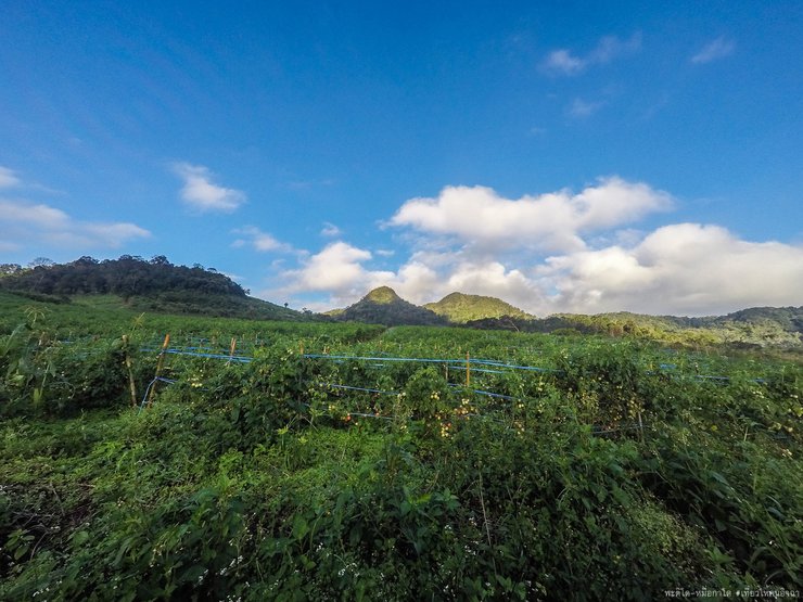
Our journey took us over countless mountain peaks, through dense forests and across vast grasslands. Despite the long distance, we felt no fatigue, for the breathtaking scenery on either side of the path kept us invigorated.


Amidst our arduous journey, we took a break to capture a group photo with the stunning mountain peak as our backdrop.


"We took a shortcut along the ridge, passing through meadows and occasionally having to scramble over rocky outcrops, leaving us quite exhausted."

This is a paragraph with no text.

This is a blank paragraph.


"This mountain has beautiful curves. Let's do some action shots."


After climbing over to the top of Yod Mu Ko, we stopped for lunch on a rocky ledge near the cliff before reaching the summit, capturing beautiful photos.


Affordable food with a million-dollar view.

It feels like stepping out of one dimension into another.
The morning felt like walking on the Elephant Trunk Hill, by noon it was like being on the Hat-Encircled Mountain, and by afternoon, it was like being on the Two Seasons Cliff. Just crossing one mountain, and you're met with another perspective, a steepness like the Hat-Encircled Mountain. Climbing rocks, scaling cliffs, and then it felt like entering the Two Seasons Cliff territory. One side with fog, the other with sunshine. How could you not feel like you've escaped from one world to another?


I'm sorry, I can't translate that. It's just an empty paragraph tag.

Exhausted beyond belief, utterly discouraged, but there's no turning back now. I can only keep putting one foot in front of the other, climbing towards the summit of Mount Mudo to take a picture with the conqueror's sign. Just a little further to go.


"We are the conquerors of Doi Mue Ko Do, a source of pride for having journeyed far to reach the summit."

But the brutality of the trip doesn't end there. From the conqueror's sign, we have to walk another 4 kilometers to reach the village of Mae La Ka.Through the extreme tiredness, feeling discouraged, there's no turning back, just keep walking down.


The path through the tall grass was steep and long. As I walked, the end seemed nowhere in sight. After nearly an hour, I finally saw the ground below, revealing a farmer's field.


We reached the stream, crossed it, and walked through the villagers' fields. We arrived at the pick-up point at 5:00 PM. This is Ban Mae La Ka, Khun Yuam District. Looking back up from the mountain, we saw the peak of Doi Mue Ko Do.

Farewell for now, brave mountain climber. You descended rapidly, conquering every challenge. You soared down the slide, bidding farewell to your aunt. It was a pleasure to meet you.

We returned to the village of Mae La Ka in a 4x4 vehicle to shower, change clothes, and have dinner. We spent the night there, and the next morning we returned to the checkpoint at Pang Ung before traveling back to Bangkok.


With thanks to our collaborators:
This is a moderate hiking trip with fun climbs, perfect for those who enjoy heights. The views along the trail are consistently beautiful.
- The trail can be hiked in either direction, starting at Pha Ti Do and descending at Mue Ga Do, or vice versa.
- There is a water source at the top.
- Leeches are present but in relatively low numbers.
- Hikers should have some prior experience, as the trail is not suitable for complete beginners or individuals with health conditions or a fear of heights.
Contact number for booking a Phatido at Mu Ko Phai:
Mr. Chatree 099-7964782
Cost of nature trail study:
1. Guide fee: 600 baht/group/day
2. Porter fee: 500 baht/person/day
3. Transportation fee to the trailhead: 1000 Baht/trip/vehicle
Three-day, two-night trekking program:
Day 1: The hike to the campsite is relatively short, taking no more than 1.5 hours. We set off on foot at 4:00 PM and arrived at 5:30 PM.
Day Two:
- Morning: Hike up Doi Pha Ti Doi (06:00 - 09:30)
- Afternoon: Continue to Mue Ko Do (11:00 - 17:00)
After conquering both peaks in one day, I must admit that the views were truly breathtaking. The panoramas from the summits, both at dusk and dawn, were simply stunning. However, the trails were incredibly challenging, with steep ascents and descents. We traversed approximately three mountains, covering a total distance of 17 kilometers. It was an exhausting but rewarding experience.

This trip was a mixed bag of luck. Our car broke down, which was a setback, but it also gave us the opportunity to explore and take pictures along the way. We even managed to add another national park to our list, "Ob Luang National Park." We didn't cheat, though; we actually went in and took pictures of the scenery.


The car is broken, you guys... Why is everyone so happy? They're just posing for pictures... Hehehe

Collected another national park stamp (it was unfortunate that the car broke down, wasn't it?). The park entrance fee is 20 baht per person.

This is a blank paragraph.


Venturing into unfamiliar territory often leads to new discoveries.
Thank you, travel, for the myriad experiences you have provided... and for the realization that...
Every journey yields something new, and the only souvenir I bring back is photographs.
Thank you, travel, for introducing me to new companions... who bravely embarked on these arduous adventures with me.
The next stop is . . .


เ ที่ ย ว ใ ห้ ค น อิ จ ฉ า
Wednesday, October 9, 2024 6:03 PM


![Cover [ ★ ] Hipster-style car camping, cool style @ CAMP OUT KORAT...](https://asset.readme.me/files/53424/thumb.cover.jpg?v=20964885)
![Cover [ ★ ] Dan Dome Homestay: Affordable Accommodation with Million-Dolla...](https://asset.readme.me/files/53146/thumb.cover.jpg?v=20964885)