


The first words out of my mouth when my girlfriend suggested a trip to Phu Kradueng were, "Let's go!" It wasn't a particularly difficult decision, but the timing was interesting: Songkran, the hottest month of the year. Despite the scorching temperatures, I remembered boasting 20 years ago that climbing Phu Kradueng was child's play. Besides, I had been training regularly, so I figured I could handle it. And so, our spontaneous adventure began. This impulsive behavior is not recommended, and anyone considering such a feat should consult a physician first.
We started our journey from Chonburi province on the evening of April 12th. We left Chonburi and passed through Bangkok on the Mittraphap Road. The traffic was slow-moving, as expected during the Songkran festival. We passed Lam Takhong, where construction was underway, and reached Sikhio. We then turned onto Route 201 to Chaiyaphum. The road was smooth and easy to drive on until we reached Chum Phae. At this point, we had been driving for 11 hours and were exhausted. We decided to rest at a roadside hotel. After sleeping for two hours, we continued our journey to Phu Kradueng National Park. We arrived at the foot of the mountain at 9:30 AM. We contacted the accommodation on the mountain, but there were no vacancies. We considered staying in a house, but the minimum occupancy was six people. We decided to stay in a tent instead. The cost was 30 baht per person for the campsite and 60 baht per person for bedding (sleeping bag, mat, pillow). The tent rental was 200 baht. We paid the fees at the bottom of the mountain, but the equipment fees were paid at the top. If we had stayed in a house, we would have had to pay at the bottom. After paying the fees, we were free to go. If you want to hire a porter to carry your belongings, you can contact them. However, I decided to carry my own belongings, so I didn't need to do that. My luggage weighed 17 kg, and my girlfriend's luggage weighed 7 kg.
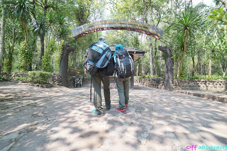
And so we have arrived at the gateway to heaven.

Today's plan is to walk at a steady pace, keeping our heart rate from getting too high. At each rest point, we will rest just enough to catch our breath before continuing. This will help prevent our legs from cramping up from resting for too long.
Ready, set, go!


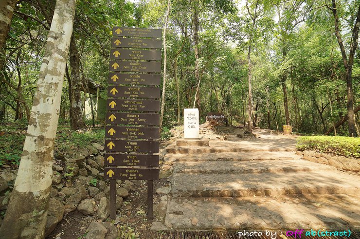
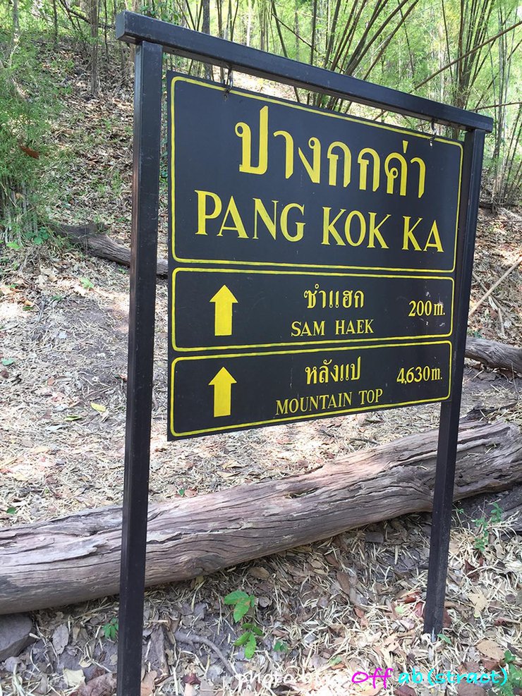
Starting my hike at 10:30 am, when the sun was shining brightly and perfect for grilling, I walked very slowly to avoid getting my heart rate up. By the time I reached the first sign, Pang Gka, the trail was scorching hot. However, I noticed that when the wind blew, the air wasn't as stifling.

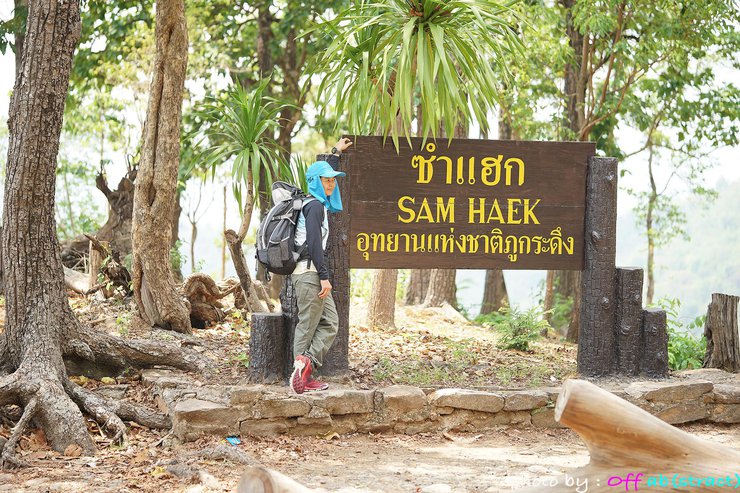
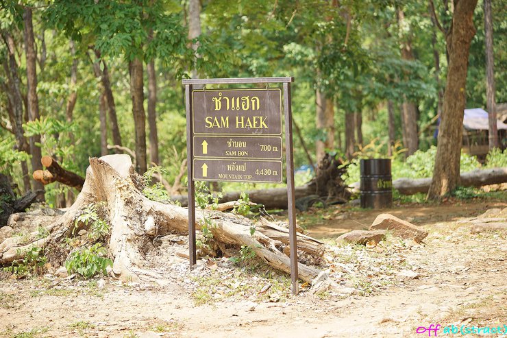
And then we arrived at the first point, Sam Haek. The sign indicating the steepness of the climb made it clear that we still had a long way to go. After resting for a short while to regain our strength, we continued our journey immediately. We continued to use the method of walking with short steps, without stopping.


The next stop is Sam Bon. The trail remains the same, but the incline is more manageable, likely due to the challenging climb we just completed at Sam Haek.
There is no official rest stop here. The sun is occasionally obscured by clouds, making it less suitable for grilling.

The next day, there was still nothing to eat, only the increasing steepness.
The sign reads "Sam Ko Sang in 200 meters," but I can't help but wonder why it feels like it's taking forever to get there.

We finally reached the resting point, Sam Ko Sang. Today, only three shops are open. We stopped to drink water and add sugar with red soda. The vendor told us that the next point with shops is Sam Krae.

At this point, we have caught up with the group of children. This section is called "Phra Nang Pran Pa", and it is an easy walk on a concrete path. However, be warned, the incline is no joke.


The journey through the dense forest was challenging, with aching shoulders from carrying heavy loads and the constant temptation of grilled food.
Upon reaching Sam Kok Wua, we were exhausted. Fortunately, the weather was cool, so we took a break with the porters. However, the shops were closed. As we recovered, we continued our journey.

And then we arrived at Sam Kok Don, where there were houses for officials, a restaurant that was not open, traces of electric wires to prevent elephants, and large trees growing.
We're almost there. Let's take a short break and then continue.

I personally enjoy this section of the trail. It feels like a dense forest, providing ample shade and keeping the temperature comfortable. Upon reaching the salt lick, we took a break to replenish our electrolytes and carbohydrates in preparation for the challenging ascent after the meadow. We were even greeted by some local wildlife.

As you approach the back of the temple, the path gradually becomes a series of stairs. The final stretch features a long, exhilarating staircase.

After a 5.5 km hike from 10:30 to 14:00, we arrived at Lang Pae. To our disappointment, the restaurant we remembered from 20 years ago was gone, replaced by a small drink stall. We bought a cold drink (30 baht) and took some photos before continuing our 3 km walk to the Vang Kwang campsite.

Upon reaching Wang Kwang, we entered the tent to eat, and then continued walking to Pha Mak Duk to see the view.
A comfortable 2 km walk. One thing I noticed about the changes on Phu Kradueng today is that there are more trees. This is probably why I felt cool all the time, even though the vendors said it was hotter than previous days. The temperature was probably around 25 degrees, even though it was already 3-4 pm.

This is the unique characteristic of Phu Kradueng: cliffs and pine trees with two or three needles.

The sentence is already in English and does not require translation.
As the sun set, the air grew cool, belying the summer heat. Eager to capture the Milky Way, I retired early, planning to rise in the dead of night.
And here is the Milky Way photographed at 2 am at Wang Kwang, with a herd of deer coming out. I didn't dare to go out far either.


The next day, due to limited time, I descended from Phu Kradueng with the thought that if I didn't know where to escape the heat, I would definitely come back again. See you again, Phu Kradueng, in April.
After descending from Phu Kradueng, I planned to photograph the Milky Way at Mo Hin Khao in Chaiyaphum. The journey from Phu Kradueng to Mo Hin Khao is not too far. On the day I went, I met many photographers. However, I would not recommend going alone, as it is quite isolated. The park officials also informed me that teenagers sometimes visit late at night.
This concludes my review of Khao Hin Khon Viewpoint. Thank you for reading. Feel free to share this review without asking for permission.


Sinard Narktubtee
Wednesday, February 26, 2025 4:27 PM